Kvarken Flada – A short summary of the projects third year, 2019
Introduction
During the third and the last year of Kvarken Flada project, we have been doing less field studies than during the last years. Instead we have been planning and conducting the restorations in flads as well as analyzed all the gathered data from previous years and writing the final reports.
Field studies 2019
During the last year of the project we have been doing field studies in a total of 15 flads (in comparison 54 flads in 2017 and 39 flads in 2018). We have continued the bat-study in ten flads as well as continued mapping the migration of the bats in the autumn with radio tags. We have also studied temperature, perch eggs and juveniles in four flads and vegetation in nine flads. These results will be compared with the results from 2017 and 2018 to see if there are differences between years.
Restoration of flads
During the projects last year, we have restored in total five coastal areas and the last restoration will be done in a couple of days. We have restored the first ever flad-treshold in Sweden, two creeks and changed two culverts in flad-areas. You can read more about the restorations under the page "Restoration".
Results of a three-year project
It is a great amount of data we have gathered during this project. We have made hundreds of holes in to the ice (to get the temperature loggers down in the sea), snorkeled tens of kilometers (to study the underwater vegetation in the flads) and went through thousands of fish larvae and insect samples, recorded tens of thousands bat noises, tagged tens of bats and soon we have done six restorations in the coastal areas. Together we project workers, fieldworkers, students and consultants have changed the samples in to numbers with months of work and now finally can the researchers in the project analyze the data and unveil new interesting facts about the shallow coastal bays of the Quark. The results will be reviled in our final seminar on 19 of November 2019 in Vasa as well as in the final reports that will be published in the next months.
Kvarken Flada – A short summary of the projects second year, 2018
A large part of the worktime in this project goes to gathering data of the shallow coastal bays (flads) to be able to identify the most important types of flads for fish production and for the diversity.
During the field season 2018 we have studied in total 39 flads of which 18 are same flads that we studied last year. The reason to why we have revisited these flads is to se the changes between years in what it comes to temperature, fish production and insect production. During the year 2018 we have even looked at the functioning of the flad in more detail. We have sampled sticklebacks at the same time as the perch larvae hatch. Sticklebacks can have a large negative impact on the survival of the perch larvae through predation and competition of food. We have also studied the migration of the fish juveniles out of the flad to the sea as well as the fish juveniles that stay in the flads during the summer.
A lot of the flads that we have studied are affected by humans. How big impact humans have in these areas is also something we are looking at but even how we can restore flad-areas. One of the main goals in the project is in fact to develop methods for restoration and restore at least four areas in total on the Finnish and Swedish sides of the Quark. The restorations are planned to be executed next year, 2019.
Kvarken Flada – A short
summary of the projects first year, 2017
Introduction
The whole work started with identifying all the
shallow and bays in the Kvarken region. Of these over 2500
objects 54, undergoing different scaled human pressure, were chosen for our fieldwork (read more about GIS in Kvarken Flada). In these bays we have investigated fish migration, the occurrence of
perch roe, juvenile fish, underwater vegetation, insects and bats. We have also
been measuring the temperature in the bays since the end of march until the
start of October. The aim of these investigations was to increase the knowledge
of the nature values of the bays, as well as to be able to identify the most
valuable bays for example fish reproduction and diversity. This kind of
knowledge is of extreme importance for decision makers that are then able to
target right conservation measures on the especially valuable areas.
Fieldstudies 2017
Temperature measurements
At the end of March over 100 stationary temperature
loggers were placed under the ice. The loggers recorder the temperature in the
bays and outside of the bays to see, how mych faster the bays warm up than the
outer areas. The temperature plays an important part in the spring when pike
and perch are reproducing since they tend to search for the warmest possible
areas for the juvenile fish to grow in.
Fish migration, roe
and juveniles
At the end of April and start of May the
migration of pike and perch in to shallow bays was monitored at 5 different bays. When the spawning had finished we
investigated the roe on the beaches of 19 different bays.
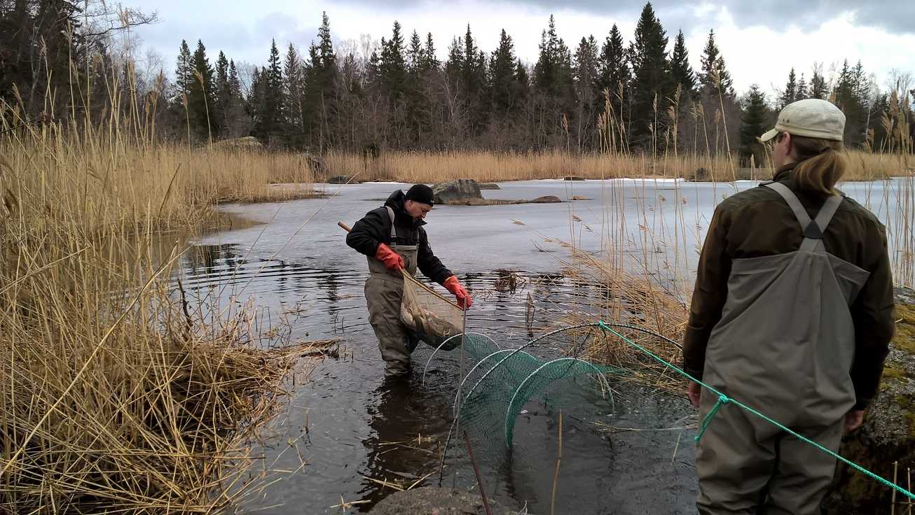
After the
hatchment period 52 different bays were sampled for the amount of pike and
perch juveniles. The sampling was conducted 2-3 times under a period of three
weeks. Spring came late which made it hard to estimate the right time for
hatchment. Perch were caught with a net and pike with a special net designed
especially for the purpose of finding juvenile pike in the shallow vegetation
area.
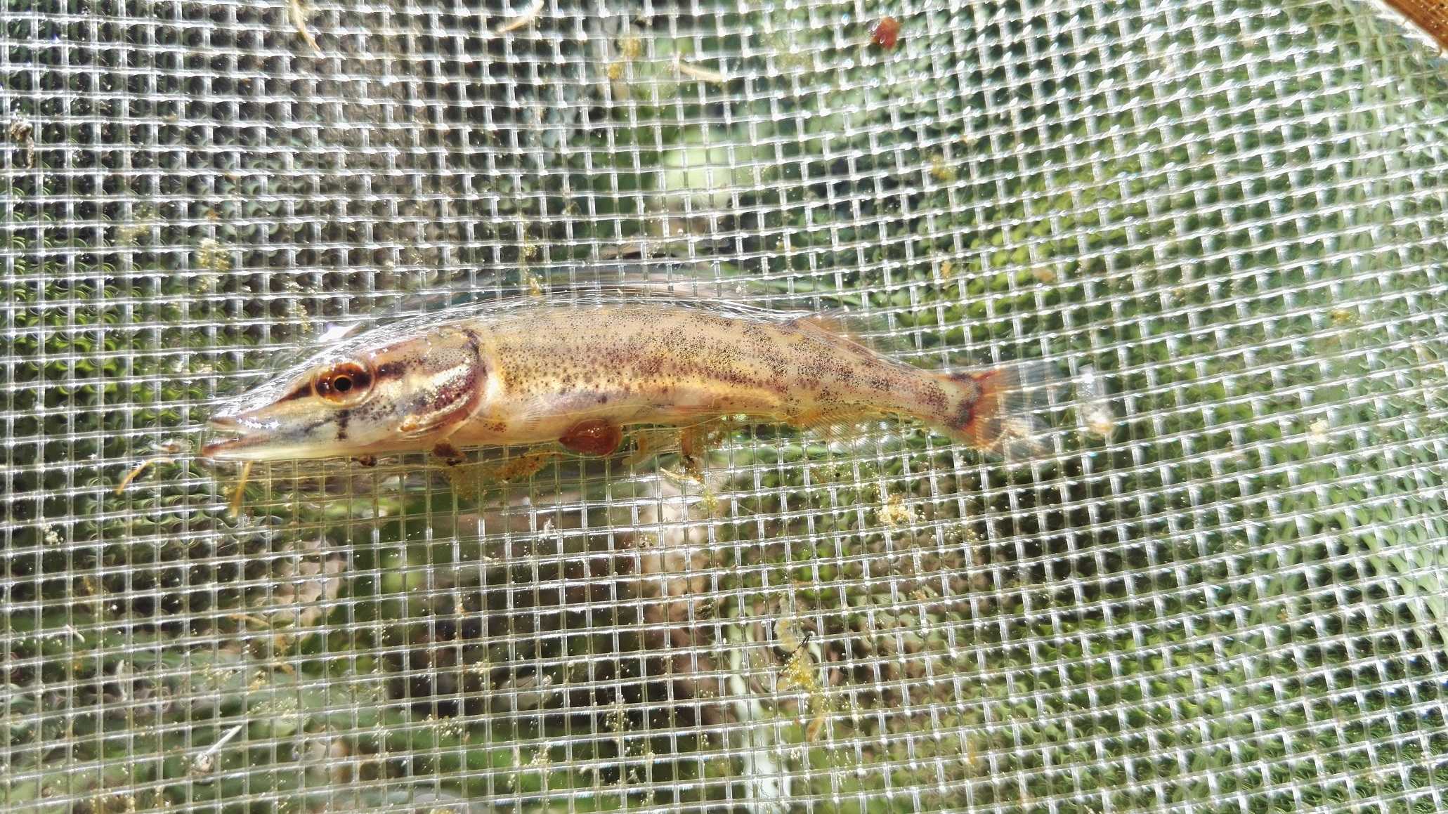
The
sampling resulted in total with approximately 700 samples that are meant to be
counted, identified and measured during the winter. The size of the juveniles
may vary between 4-20mm depending on the the species as well as the date of the
sample (age of fish). Species and groups that we can find in our samples are
pike, perch, cyprinids, burbots, whitefish, Coregonus
albula, Baltic herring, smelt, stickleback and others.
Insects and bats
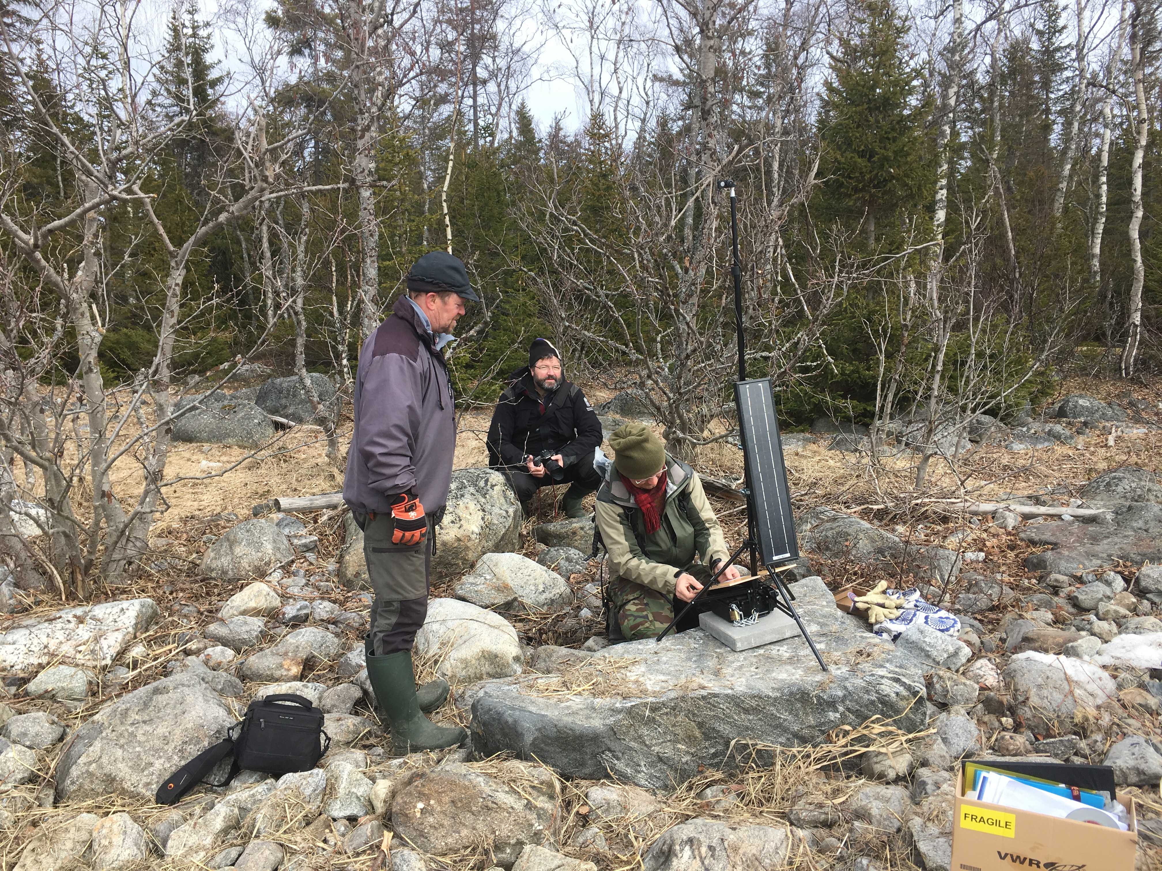
In the start of May insect traps and passive
bat detectors were taken out to 10 different bays. Bat detectors were also laid
out in the outskirt of the bay areas. The detectors got energy from solar
panels, a microphone recorded possible bats ultrasound on a memory card. In
each bay three insect traps were set up. Two emergence traps on the water
surface and one Malaise trap on land. The purpose is to identify the time of
highest insect abundancy and if this correlates with bat occurance. Now there are thousands of hours
sound records and 600 insect samples to go through (read more about insect and bat surveys).
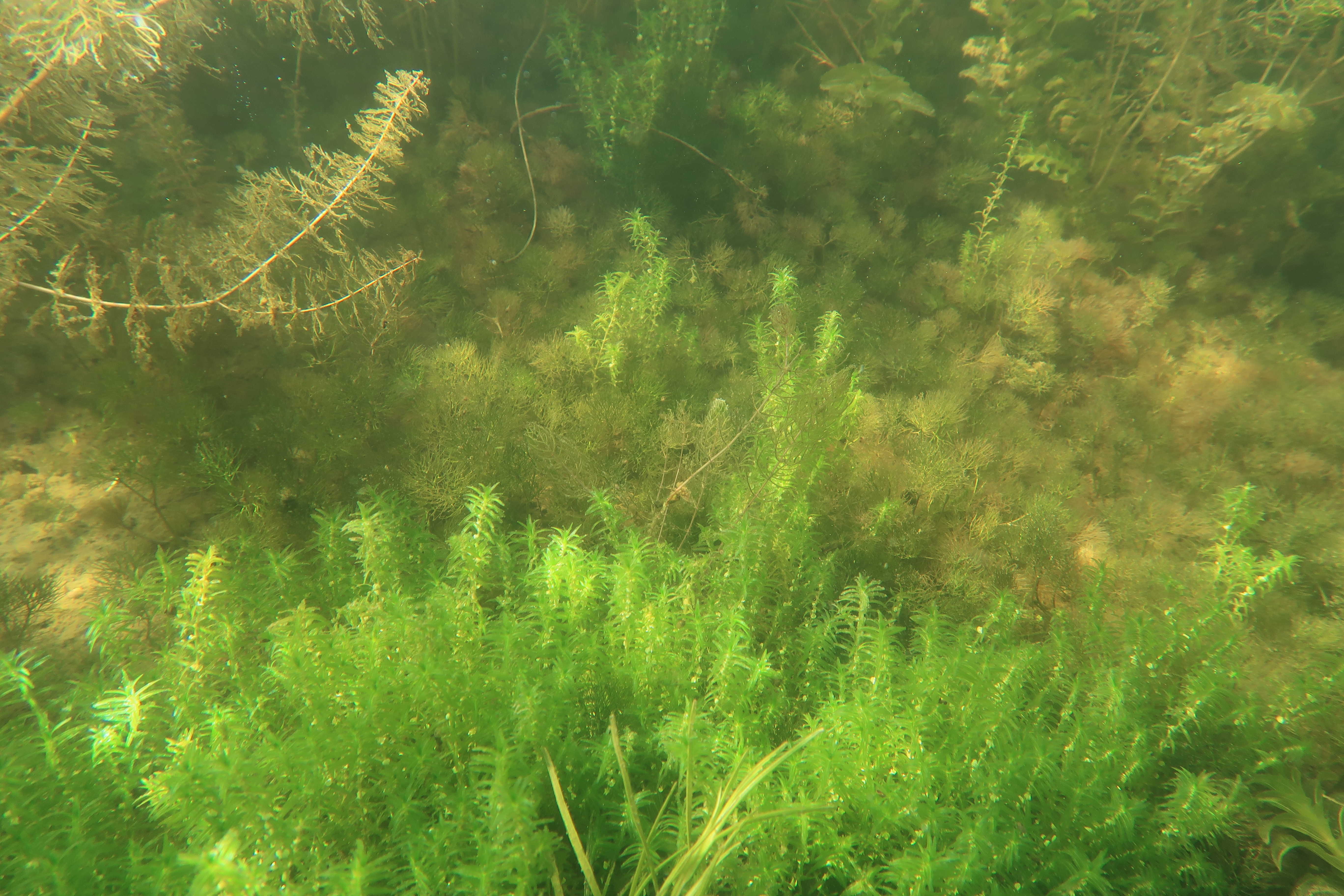
Underwater vegetation surveys
The
vegetation beneath the water surface was studied in 52 bays during July and
August. In every bay more or less 70 points were surveyed by a snorkeler. The
vegetation was identified and its procentual coverage on a square of 50x50cm
was estimated. All the bays were also photographed from a height of 50 m with a
drone so that detailed vegetational maps can be achieved. It is possible to identify
areas of vegetation in the drone pictures and combine it with the information
collected by the snorkeler. This can for example tell us which species dominate
on certain areas. The vegetation plays an important part for fish and other
animals as an habitat and food source, but some species also indicate about the
water quality. Red listed species were found on some of the surveyed areas (read more about underwater vegetation surveys).
Co-operation between
Finland and Sweden
All fieldwork was conducted in both Österbotten and Västerbotten and all
the collected data will be analyzed together. So that certainty existed of
using exactly the same methods, several meetings for training purposes were
held.